
Explore the extensive trail network and discover new places in the Key’s Great Outdoors!
On Perdido Key, you’ll discover nature at its most beautiful- a world of nature trails, endangered birds, marine life, and 16 breathtaking miles of dazzling white coastline. The pristine island is surrounded by a state park system that was voted “Best in America; for its federal parks, hiking trails, and iconic wildlife. Here, your outdoor excursions may range from an easy day trip to an extended nature weekend of campfires, stargazing, and nighttime discovery.
More than 60 percent of the Key is preserved for public use, giving nature lovers the year-round opportunity to explore wildlife refuges, natural wetlands, sanctuaries, and nature parks. The Key is a renowned habitat for nesting birds, newly-hatched sea turtles, butterflies, dolphins, rays, and more, and many species are endangered and protected under federal law.
Several sites in Perdido Key are listed on Florida’s Great Birding and Wildlife Trail (FGBWT) a 2,000 mile, self-guided trail encompassing 500 sites including one of the FGBWT’s premier Gateway sites, Big Lagoon State Park. Covering 655 acres, the spectacular park separates Perdido Key from the mainland and beckons visitors to camp, swim, fish, boat, canoe, and hike, or try crabbing in the shallow waters of Big Lagoon (also a great wading spot for toddlers).
Climb the three-stories-high observation tower there and watch for dolphins, but stop by the ranger station first-binoculars are available to loan there.
Looking for discoveries and trails in the Perdido Key Area?
Check out this list of seven unique trails in the area. Always remember to bring good shoes, as some of these trails could have portions of loose sand, and some could be wet. Also, be sure to bring sunscreen!
We hope you enjoy hiking in Perdido- be sure to take lots of pictures!
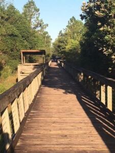
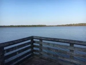
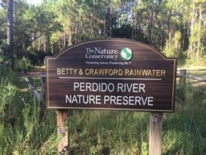 If you want to really experience natural Florida, you could do worse than hike this trail. Bette and Crawford Rainwater donated the 2347-acre property for a nature preserve, which the Nature Conservancy now manages. The 2.8-mile trail is not a loop. It traverses pitcher plant bogs, crosses managed longleaf pine forest, and terminates at an old bridge near Perdido River. The hiker will see various native plants along the route highlighted by the amazing white top pitcher plants. Birds and butterfly viewing will be good in the spring and fall. We have seen evidence of whitetail deer, coyote, and bobcat here. There are numerous information signs to educate you about the ecosystems you are experiencing. The trail is 2.8 miles from the parking lot to the terminus near the Perdido River. Half the trail is in a wooded environment, half in the open sun – so sun protection is a must, as is insect protection. We recommend bringing snacks and water. At the trail’s terminus is a covered pavilion where the hiker can rest before the return trip, but there are no seats. The trail is basically flat, hard sand, but some sections can be wet, so you should be prepared for that. Ticks are an issue, and everyone should do a tick check when they return to their car. You should plan 3-4 hours for this hike.
The trailhead is located at 5955 Hurst Hammock Road near Beulah, FL. Click here for Map directions
The Emerald Coast Utility Authority operates a wastewater treatment facility on Bayou Marcus just off Blue Angel Parkway. This facility treats 8.2 million gallons of wastewater per day. But unlike many other facilities, it discharges its treated effluent into a 1000-acre wetland where it is naturally treated further before reaching Perdido Bay. They have built a boardwalk that travels along the edge of this wetland for 1.2 miles. Hikers can find the trailhead near the front gate of the treatment plant. It begins as an easy gravel path before becoming an elevated boardwalk. Along the boardwalk, the hiker can view various wetland hardwood trees, aquatic plants, and pines. 70% of the boardwalk includes a large pipe that discharges treated water onto rock piles, where it then flows into the wetland.
Early morning and later afternoon hikes, you might find various reptiles that you can safely view from the boardwalk. This is part of the Audubon Florida Birding Trail and, thus, has a great variety of birds. There are hard copies of the FWC bird checklist at the trailhead for those interested. About halfway down the one-mile boardwalk are a handicap-accessible parking lot and access. Visitors can access this from Alekai Drive.
The boardwalk is wide enough to accommodate everyone. Bikes are allowed, but no motor vehicles, and all dogs must be on a leash. It is a wooded trail, so breezes are not strong, and direct sun exposure is mostly during the middle of the day. The hiker should still be prepared for heat and biting insects. The nice thing about the elevated boardwalk is that ticks are not an issue. Click here for Map directions.
You can spend a day or two hiking in this wonderful park. The 4290-acre preserve is part of the Big Lagoon State Park system. The trail begins in the maintained pine Flatwoods with acres of open saw palmetto and scrub. The beginning of the trail is a concrete path that is 0.2 miles long. At this point, you can take the Perdido Trail to the right for a 7.2-mile loop or continue on the Tarkiln Trail for another 0.3 miles. The last 0.3 miles of the Tarkiln Trail is on a boardwalk. It moves from the pine Flatwoods to a beautiful whitetop pitcher plant bog before reaching a hardwood oak hammock and ending at a platform overlooking Bayou Tarkiln.
 The Perdido Trail is a mix of hard and soft sand paths with some wet areas. It is well-maintained and usually mowed. There are white trail markers for you to follow as you meander through the pine Flatwoods to the live oak hammock along the shore of Perdido Bay. A portion of this trail does skirt the fence of Blue Angel Recreational Area, a private Department of Defense property. At mile marker 2.2, you can turn right and reach Perdido Bay – the actual trail continues to the southwest – following the white trail markers.
There are numerous species of flowers, butterflies, and an assortment of wildlife viewed along this trail. In addition, there are plenty of birds for the bird lover. Much of it is within the forest canopy; however, the canopy is somewhat open. This allows for cooling breezes, but also sunlight. The hiker should be prepared for sun and insect protection, bring at least a liter of water (we would recommend a camel pack), and wear shoes that may get wet. The Tarkiln Trail is handicap accessible, but the Perdido Trail is not. There is one restroom at the trailhead.
The trailhead is located on the west side of Bauer Road, about 2.5 miles north of Sorrento Road. The park opens at 8:00 AM and closes at sunset. There is a $3.00 fee for vehicles, and it is on the honor system. If you have a state park pass, you need to write your card number on the form to deposit in the box and on the mirror hang. Click here for Map directions.
Maybe you enjoy the outdoors, but not enough to hike 2-3 miles. If this is the case, The Way is the perfect trail for you. The entire trail is 0.13 miles long. The trailhead, and terminus, are both located in the back parking area of the Perdido Bay United Methodist Church. The trailhead in the far northeast corner of the parking lot begins as a boardwalk and is handicap-accessible. The trail meanders past cypress and pitcher plant bogs as it works its way towards Bayou Garcon. At the bayou, hikers will view salt marsh and estuarine plants and wildlife before the trail heads back towards the church. Along this last leg, the boardwalk gives way to a maintained chip trail. This trail often could be traversed with a wheelchair, but you should check it to make sure. This portion of the trail winds through hardwoods before reaching the parking lot. It is amazing how many different habitats, and wildlife, you can experience in such a short distance. There is an information kiosk at both ends. The trail is partially shaded, but you should consider sun and insect protection here. There is plenty of parking but no restroom facilities. Perdido Bay United Methodist Church is located at 13660 Innerarity Point Road.
 This trail is actually is part of Perdido Key State Park and does not have an official name. However, it is located at the end of Lafitte Reef Road off Perdido Key Drive. The trailhead is at the corner of Lafitte Reef and Bowlegs Reef road. There is a small parking area (for about three cars) and a fenced switchback to allow hikers in. The trail is 0.8 miles to the terminus and is not a loop. It is well marked with orange arrows, and there is a bench at the terminus. Along the route, the hiker will venture through a dune scrub habitat, including pines, live oaks, and palmettos. Some low wetland areas are along the path, and some parts of the trail could be wet. Old River is just north of the trail, and the hiker will have several chances to view it. Here pelicans and osprey are often seen, as well as jumping mullet. Much of the trail is soft sand, so it is not handicap accessible and will require good hiking shoes. It is also very open, with a lot of direct sunlight. The hiker should have sun and insect protection, as well as plenty of water. There are no restroom facilities here. To find the trailhead, turn north on Lafitte Reef Road, just west of the Perdido Key Visitors Center. Drive until the road heads west and becomes Bowlegs Reef Road. The trailhead will be to your right.
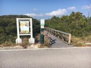 This trail is located within the Gulf Islands National Seashore / Johnson’s Beach area. You will need a national park pass or pay an entrance fee to access this trail. The trail is short – 0.4 miles – and the entire route is a railed boardwalk, so it is handicapped-accessible. The trailhead begins in a maritime pine forest and meanders through a live oak/dune scrub habitat. You will find one pull-off area that overlooks the salt marsh of Siguenza Cove and includes an information kiosk. The trail then winds through a scrub dune system, and you can see the primary dune field, covered with sea oats, to the south. It terminates at the road, and you can either back-track the boardwalk to your car or take the short walk down the road. This trail is open to the sun, so sun protection is needed. To find the trailhead, enter the park and take the first left. There is a sign there telling you the Discovery Trail is this way. Follow the short road to the parking area and trailhead. There are restrooms and picnic tables on the Gulf side across the street. The Johnson’s Beach portion of Gulf Islands National Seashore is located where Perdido Key Drive heads north towards the Theo Baars Bridge. 13333 Johnson Beach Road.
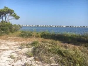
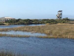
There are several great trails in this great state park. The first is an easy boardwalk trip around the small lagoon at the east beach. There is plenty of parking here, a restroom, and even an outdoor shower. The boardwalk loops but terminates at one of two pavilions. To connect the two pavilions, you will need to hike through soft sand. This boardwalk crosses over a saltmarsh ecosystem. From the elevated boardwalk, you will be able to see a variety of fish, blue crabs, birds, and maybe even a diamondback terrapin. Along the south boardwalk is a 3-story observation tower where you can view Big Lagoon and much of Perdido Key. From here, you can see the extensive seagrass beds of the lagoon, fish, birds, and maybe even a manatee or stingray. This trail is completely open to the sun, so sun protection is needed. There is a water fountain near the restroom. The trailhead is located at the end of the road at the east beach parking lot.
At the northwest corner of the east beach parking area is the trailhead to the orange trail (so named for the orange trail markers used here). This 1.1-mile trail extends from east beach parking to west beach parking. Along the way, there is a connection to a blue-marked trail that leads to a pavilion on the lagoon. The trail is mostly opened to the sun, so sun protection is, again, a must. You should also bring water with you on this one. It is a sandy trail and not suitable for wheelchairs, and there is some elevation change along its path – a rare thing on the trails in this program. The hiker will experience a scrub dune habitat with various small bushes, flowers, birds, butterflies, and stunted live oaks trees. Towards the terminus, the trail goes beneath a pine/oak hammock, giving protection from the sun but blocking the breeze. The trail terminates at a boardwalk along Long Pond, where you can either head south to west beach parking (and another restroom, shower, and water fountain) or north to the campground. Heading north will take you across Long Pond, where you can observe fish, birds, turtles, and maybe an alligator.
Just to the north of the Pond (before you reach the campground), you will find another trail. You will hike a loose, sandy path back to the lagoon (about 1.0 mile) east on this trail. It is a mix of open sun and tree-covered walking. This portion of the trail hugs the shore of Long Pond, and the hiker could encounter reptiles, amphibians, and always birds. There is a pavilion at the lagoon, and the trail continues to join the longer 3.0-mile loop of the entire park. This trail circumnavigates the park’s boundaries with several elevation changes and experiencing both open sun and tree hammock shade. The path is sandy and can be wet. We recommend good hiking shoes that can get wet, sun and insect protection, and plenty of water. The loop returns to the boardwalk at Long Pond. The best access to this trail is to park at west beach parking, cross the street to find the boardwalk portion of the trail.
Big Lagoon is located on Gulf Beach Highway just across the Theo Baars Bridge, 12301 Gulf Beach Highway. The park opens at 8:00 AM and closes at sunset. There is an entrance fee to access this park.